Showing posts with label uniformitarianism. Show all posts

Angular Unconformities

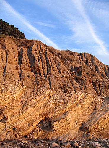
Another question for the YEC uplift model used to previously explain vertically uplifted strata is how does this deal with angular unconformities? If sediments were uplifted in a quasi-mud state and were pliable enough to allow this to happen quickly and subsequently turned solid after the flood how do we get explain formations like this:


Here we can see clearly uplifted sedimentary rock on the bottom with more layers of horizontally non-uplifted sedimentary rock capping it. If all these sediments were laid down prior to uplift they should all exhibit the same basic features, if the bottom section was uplifted while pliable and then the top layer dumped on top wouldn’t the bottom layers bend under the weight? After all, they are supposed to have been quasi-mud, not rock when all this occurred. Or are these formations explained with the top sedimentary rock having been deposited after the flood, and the near vertical layers below had solidified?

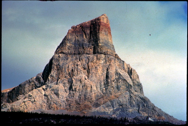
More examples of angular unconformities:


The standard model of angular unconformities explains them as layers of sediment compressed into sedimentary rock over long periods of time which were then uplifted at about the same speed your fingernails grow. Erosion then wore down the exposed uplifted rock until the environment changed to a depositional one. New sediments were added on top of the uplifted layers and were eventually buried and compressed into new layers of horizontal sedimentary rock capping older uplifted layers of sedimentary rock.

http://www.glossary.oilfield.slb.com/DisplayImage.cfm?ID=4

Polonium Halos

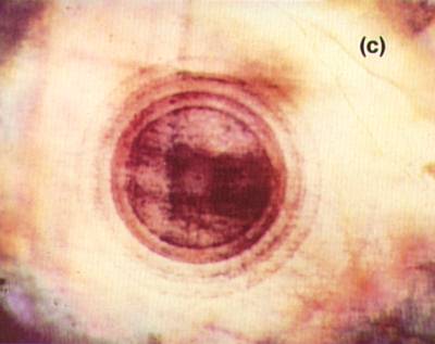
The term “polonium halo” refers to a ring of damaged material where the emitted particles from a piece of radioactive material has basically messed up the surrounding rock. Since the size of the ring is related to the energy of the radiation it should be possible to determine what the radioactive material was that formed a given ring. Gentry looked at polonium halos in granite and concluded that since it takes millions of years for present day decay rates to form a “halo” and because Polonium isotopes have really short half lives (Po218 = 3.05 minutes, Po214 = >200 microseconds, Po210 = 140 days) that this was evidence for an increased rate of radioactive decay.

The problems that strike me are that there’s no mechanism for increased radioactive decay proposed, there’s no mechanism for getting rid of the huge amount of heat that would result from all that radioactive decay happening so quickly, and there’s no mechanism for dealing with the lethal amounts of radiation this would have produced. Finally, there’s a very plausible alternative that avoids all of these problems – Polonium halos are invariably found near uranium halos which makes sense since the isotopes we’re talking about here are all part of the decay series of various isotopes of Uranium.


The immediate precursor in this decay series is Radon, a gas that is quite soluble in water and easily diffuses through small fractures in rock. A steady amount of Uranium decay will produce a steady stream of radon which will steadily decay into polonium which will steadily emit particles as it is formed and quickly decays. I’m no geologist, but that seems like a pretty straigtforward explanation that works a lot better than proposing an unknown decay rate increase mechanism ostensibly offset by some unknown force to remove the huge amounts of heat and radioactivity it would produce.
http://www.csun.edu/~vcgeo005/revised8.htm

When you look at Gentry’s halos you can see numerous rings showing clear sings of Radon and Polonium decay entirely consistent with Radon decaying into Polonium and creating rings along the way.


I’ve seen this argument handled by geologists before, a good discussion of it can be found here:

http://www.evcforum.net/cgi-bin/dm.cgi?action=msg&m=162875

With some particularly pertinent posts on evidence for Radon here:

http://www.evcforum.net/cgi-bin/dm.cgi?act…6261&mpp=15&p=8

Formation of the Hawaiin Islands

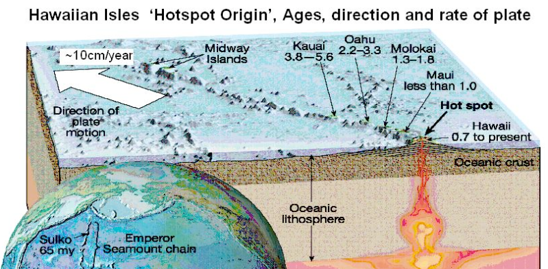
The Hawaiin islands are made up of 107 volcanoes stretched across 1500 miles of the Pacific Ocean. They were formed over about 70 million years by the movement of the Pacific plate to the Northwest over a stationary hotspot where magma wells up from the earths mantle.


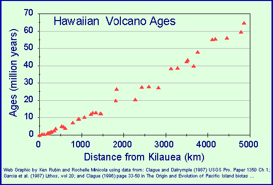
This means that the further away from the hotspot an island is the older it should be, and this is borne out by observation. First we can use radiometric dating to get absolute dates for each island, which look like this:

(source)


Consequently, if we then run the clock backwards using near-present day rates of 3.4 inches a year these dates coincide with those islands being over the stationary hotspot.

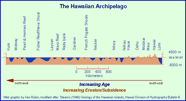
Second, and this is one you can do yourself, we can look at the amount of erosion and weathering that have taken place. Obviously the older an island is the more eroded it should be with the oldest islands actually having been flattened by waves and eventually sink below the surface. This is exactly what we find.

(source)

The later point is something that’s pretty easily observed even without any complex understanding of radioactive decay or weathering.  For example, here’s Hawaii, one of the youngest islands in the chain, notice the nice tall mountains:


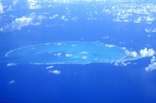
Now let’s jump to one of the last (oldest) islands in the chain, Kure:


Notice a difference in the amount of erosion that's taken place?

Even the ancient Hawaiins believed that the islands got younger as they approached Hawaii,
“The possibility that the Hawaiian Islands become younger to the southeast was suspected by the ancient Hawaiians, long before any scientific studies were done. During their voyages, sea-faring Hawaiians noticed the differences in erosion, soil formation, and vegetation and recognized that the islands to the northwest (Niihau and Kauai) were older than those to the southeast (Maui and Hawaii). This idea was handed down from generation to generation in the legends of Pele, the fiery Goddess of Volcanoes. Pele originally lived on Kauai. When her older sister Namakaokahai, the Goddess of the Sea, attacked her, Pele fled to the Island of Oahu. When she was forced by Namakaokahai to flee again, Pele moved southeast to Maui and finally to Hawaii, where she now lives in the Halemaumau Crater at the summit of Kilauea Volcano. The mythical flight of Pele from Kauai to Hawaii, which alludes to the eternal struggle between the growth of volcanic islands from eruptions and their later erosion by ocean waves, is consistent with geologic evidence obtained centuries later that clearly shows the islands becoming younger from northwest to southeast.”
(source)

Subsequent Note:


A noticeable shift in the Hawaiin-Emperor Seamount chain was caused by the Pacific plate changing direction from 50 to 42 million years ago. As with the Hawaiin chain the trend of consistently older radiometric dates continues as does the relative amount of erosion.
(source)

Further reading material:
http://www.soest.hawaii.edu/GG/HCV/haw_formation.html
http://www.enotes.com/earth-science/…land-formation
http://hvo.wr.usgs.gov/volcanoes/